Specialty and competitive programs
Historic Roadside Properties and Waysides

The Historic Roadside Properties Program funds the repair, rehabilitation and preservation of roadside properties that are either listed on, or eligible for, the National Register of Historic Places.
Projects were identified by a series of cultural resources studies of historic roadside development properties conducted in 1996-1998 by Gemini Research for MnDOT. A supplement released in updated on 2005 with amendments in 2006 and 2009. A study of properties constructed prior to 1975 was completed in 2016 by Stark/Deco. A new cumulative study which combines all previous reports and updates selected sites was released in 2020.
The 2020 study identified 243 MnDOT properties, of which 21 are either listed on, or eligible for, the National Register of Historic Places and still owned by MnDOT.
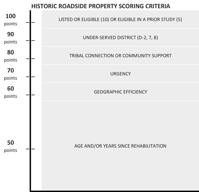
In addition to the scoring criteria, other factors are also considered in selecting historic property rehabilitation and repair projects. For example:
- It is not unusual for historic structures located close to the roadway to be struck by vehicles. In these cases, the historic property will be repaired as soon as possible under program guidelines and within available funding.
- Occasionally a property will be found to be deteriorating at a faster rate than anticipated and repairs must be accelerated in order to avoid losing the structure.
- Local Government agencies, community groups or individuals may request that a structure located close to their municipality be restored and may contribute funding.
What’s been selected?
Related links
How the projects scored
The construction costs shown on this list represent a very high level estimate based on information available at the time selection decisions were made. Actual construction and delivery costs will change over time as projects go from a concept through the project development process and are eventually constructed. View more detailed scores (Excel).
Last updated July 2025
| Score | Site Name | Project Construction Year | Planning Level Project Estimate | Scope and Project timing notes |
|---|---|---|---|---|
| 85 | Birch Coulee Historical Marker (HM) | 2027 | $ 250,000.00 | N.A. |
| 80 | Chatfield HM | 2026 | $ 250,000.00 | N.A. |
| 80 | Hewitt Roadside Parking Area (RPA) | 2028 | $ 500,000.00 | SP 7709-18 roundabout at 201-71 in 2026, DNR work at dam also in 2026 |
| 80 | Maiden Rock HM-Frontenac-Lake Pepin Rest Area (Class 1) (RA) | 2026 | $ 750,000.00 | N.A. |
| 80 | Morton Pioneer Monuments RPA | 2027 | $ 100,000.00 | N.A. |
| 80 | Vineland Historical Marker | 2029 | $ 300,000.00 | N.A. |
| 70 | Avoca Historical Marker | 2030 | TBD | N.A. |
| 70 | Burgen Lake RA (W.B.) SP2180-133 Woodland Trail | 2027 | $ 200,000.00 | N.A. |
| 70 | Garrison Concourse | 2029 | $ 500,000.00 | N.A. |
| 70 | Garrison Rest Area | 2029 | tbd | N.A. |
| 70 | Graeser Park, Phase IV Overlook wall | 2026 | $ 150,000.00 | N.A. |
| 65 | Noyes Roadside Parking Area | see note | n.a. | N.A. |
| 60 | Otter Tail Lake RA-rescheduled | 2027 | $ 500,000.00 | N.A. |
| 60 | Thompson Hill-Skyline Parkway Overlook | 2029 | $ 400,000.00 | N.A. |
| 60 | Wabasha Overlook | 2029 | $ 600,000.00 | N.A. |
| 59 | Orr Roadside Parking Area-Phase II ADA Site improvements | 2028 | $ 294,000.00 | ADA Funding in 2028 Orr $194,000 |
| 55 | Christmas Lake RPA | 2030 | TBD | N.A. |
| 55 | New Ulm Spring RPA- Ph II trail | 2026 | $ 150,000.00 | N.A. |
| 54 | Willow Lake RPA | TBD | tbd | N.A. |
| 52 | St. Paul Overlook [Burns Ave] | 2028 | $ 650,000.00 | N.A. |
| 51 | Split Rock Lighthouse Overlook | 2027 | $ 250,000.00 | N.A. |
| 50 | Browns Valley Historic Marker | NP (Not Programmed) | NP | N.A. |
| 50 | Cascade River Wayside-PhII ADA Site Safety | 2028 | $ 294,000.00 | ADA funding in 2028 $244,000 |
| 50 | Stillwater - (South) Scenic Overlook/Lake St. Croix | NP | NP | N.A. |
| 48 | Redwood Falls Retaining Wall | NP | NP | N.A. |
| 40 | Preston Overlook | NP | NP | N.A. |
| 38 | Inspiration Point (Lanesboro) | NP | NP | N.A. |
| 36 | Mendota / Sibley Pioneer Church Site | NP | NP | N.A. |
| 33 | National Grange Historical Marker | NP | NP | N.A. |
| 26 | Graceville Historical Marker | NP | NP | N.A. |
| 23 | Reno Spring Roadside Parking Area | NP | NP | N.A. |
| 21 | La Crescent Overlook | NP | NP | N.A. |
| 17 | Mantorville Retaining Walls | NP | NP | N.A. |
